◄ Carnets Geol. 26 (14) ►
Outline:
[1. Introduction]
[2. The Pliocene succession revealed by the riverbed lowering]
[3. Analysis of the sandstone bed (unit 8) within the Blue Marls Formation]
[4. Integration of the data into the regional ria network]
[5. Conclusions]
[Bibliographic references]
and ...
[Plate]
corresponding author
retired from Université de Lyon, France;
6D, Avenue Général de Gaulle, F-05100 Briançon (France)
retired from Université de Lyon, France;
Geoapplication, Visan (France)
retired, formerly at Andra/DRD, F-92290 Châtenay-Malabry (France);
2, quai des Plâtreries, F-77920 Samois-sur-Seine (France)
Published online in final form (pdf) on August 8, 2026
DOI
10.2110/carnets.2026.2614

[Editor: Bruno
R.C. Granier; language editor: Stephen Carey]

Over 3.5 km south of Roaix village, the middle Ouvèze riverbed has undergone an incision of 5-9 m into its substratum since 1995. The local nesting of the river and erosion of its banks reveals a more complex geometry of exposed Pliocene deposits than previously recognised. The Pliocene stratigraphic succession includes, at the base of the classical Blue Marls, a prograding-aggrading stack of more or less nested, sigmoidal sandstone-marlstone cycles, each comprising an erosive sandstone wedge followed by a draping aggrading marlstone. Sedimentary features suggest that the main depositional mechanism for sandstone was high-velocity hyperpycnal bottom currents linked to river floods updip. These findings are presented in the context of the ria network of the Middle Rhône valley, including mostly unpublished data from the Andra (French Agency for Nuclear Waste Disposal) exploratory works in the lower Cèze valley in the 1990s. The combined data fail to support the idea of a so-called "Zanclean Deluge" during the reflooding of the Mediterranean basin after the Messinian salinity crisis.
• Messinian;
• Pliocene;
• ria network;
• hyperpycnal currents;
• cyclic steps;
• Zanclean Deluge
Ferry S., Truc G. & Brulhet J. (2026).- Recent overdeepening of the middle Ouvèze riverbed (SE France) provides new data about the Pliocene infilling of the middle Rhône valley ria network.- Carnets Geol., Madrid, vol. 26, no. 14, p. 327-341. DOI: 10.2110/carnets.2026.2614
Un récent surcreusement du lit de la moyenne Ouvèze (SE France) apporte de nouvelles données sur le remplissage pliocène du réseau de rias de la moyenne vallée du Rhône.- Sur environ 3,5 km de long au sud du village de Roaix, depuis 1995, le lit de l'Ouvèze s'est enfoncé de 5 à 9 mètres dans son substratum, alors que le cours est resté inchangé à l'aval et à l'amont. L'emboitement local du lit et l'érosion des rives ont révélé une géométrie des dépôts pliocènes beaucoup plus complexe que ce que les observations antérieures avaient reconstitué dans le bassin du Comtat. La succession stratigraphique inclut, à la base des Marnes Bleues classiques, un empilement progradant vers l'aval de cycles sédimentaires à géométrie sigmoïde, comprenant chacun un prisme à dominante gréseuse et à base érosive, suivi par un drapage à dominante marneuse. Les figures sédimentaires suggèrent que le mécanisme de dépôt des bancs gréseux était des courants de fond hyperpycnaux dans la ria, liés à des crues fluviatiles en amont. Cette découverte est replacée dans le contexte du réseau de rias de la moyenne vallée du Rhône, incluant des données restées mal publiées datant des travaux exploratoires de l'Andra (Agence nationale pour la gestion des déchets radioactifs) dans la basse vallée de la Cèze au cours des années 90. Mises bout à bout, ces données supportent difficilement l'idée d'un "Déluge zancléen" soudain lors du réennoyage marin des canyons creusés lors de la crise de salinité messinienne.
• Messinien ;
• Pliocène ;
• réseau de rias ;
• courants hyperpycnaux ;
• étapes cycliques ;
• Déluge zancléen
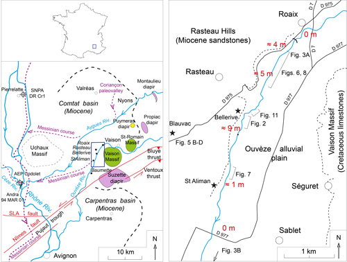
A recent incision of the middle Ouvèze
riverbed into its substratum is found just south of Roaix village, extending
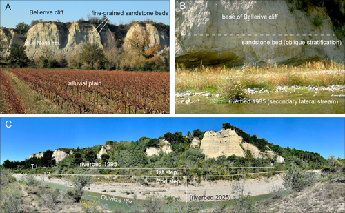
downstream for a few kilometres (Fig. 1  ). The overdeepening took place in two
steps (Fig. 2.C ) and its
cause(s) are under study. The deepening was not evident
in the 1990s (Fig. 2.A-B ) as seen in photographs taken by the first author
during Andra's geological investigations around Marcoule. The latter is a site
subsequently ruled out for the construction of an underground laboratory for the
French deep geological disposal facility project. The incision of the river well
exposed an unexpected curious sandstone body at the base of the Pliocene
infilling of the Ouvèze
Messinian valley. The Messinian valley is part of the deeply cut river network
that was carved in response to the dramatic lowering of the Mediterranean
endoreic sea level in the latest Miocene, during what is widely known as the
Messinian Salinity Crisis (MSC) (Hsü et al., 1973). G. Clauzon
(1979, 1982) proposed a now widely accepted dramatic drop in
relative sea level which occurred during the MSC throughout the Mediterranean
basin. Later studies imaged the geometry of the sedimentary system in the Rhône
River valley from far inland to deep water in the Mediterranean basin. After
decades of controversy, a two-step mechanism was inferred during the desiccation
interval (Clauzon et al., 1996; Suc et al.,
2025),
which explains the basic differences between the marginal and deep-basin
evaporites. It also explains the break in slope found from well data along the
middle Rhône ria profile, south of Pierrelatte town (Clauzon,
1982, Fig. 4).
). The overdeepening took place in two
steps (Fig. 2.C ) and its
cause(s) are under study. The deepening was not evident
in the 1990s (Fig. 2.A-B ) as seen in photographs taken by the first author
during Andra's geological investigations around Marcoule. The latter is a site
subsequently ruled out for the construction of an underground laboratory for the
French deep geological disposal facility project. The incision of the river well
exposed an unexpected curious sandstone body at the base of the Pliocene
infilling of the Ouvèze
Messinian valley. The Messinian valley is part of the deeply cut river network
that was carved in response to the dramatic lowering of the Mediterranean
endoreic sea level in the latest Miocene, during what is widely known as the
Messinian Salinity Crisis (MSC) (Hsü et al., 1973). G. Clauzon
(1979, 1982) proposed a now widely accepted dramatic drop in
relative sea level which occurred during the MSC throughout the Mediterranean
basin. Later studies imaged the geometry of the sedimentary system in the Rhône
River valley from far inland to deep water in the Mediterranean basin. After
decades of controversy, a two-step mechanism was inferred during the desiccation
interval (Clauzon et al., 1996; Suc et al.,
2025),
which explains the basic differences between the marginal and deep-basin
evaporites. It also explains the break in slope found from well data along the
middle Rhône ria profile, south of Pierrelatte town (Clauzon,
1982, Fig. 4).
|
|
Figure 1:
Location maps. Left: regional
map showing the Miocene Comtat basin, the major faults, the main diapirs and the
Messinian paleovalleys versus the modern courses of the rivers. Right:
enlargement of the study area showing the depth of the recent incision of the
Ouvèze
riverbed (red numbers, in metres) south of Roaix village and the location of
photographs in figures. |
|
|
Figure 2:
Photographic evidence of the
lowering of the Ouvèze
riverbed since 1995 south of Roaix village. A, Bellerive cliff in 1995; B, 1995
riverbed at base of the cliff; C, present-day elevation of the riverbed, about 9
m below the 1995 level, and the two pebbly terraces T1 and T2 corresponding to
the two steps of the riverbed lowering. |
The reflooding of the Mediterranean basin is a more complicated matter, with respect to both theoretical calculations and the full integration of geological data (e.g., Meijer & Krijgsman, 2005; Popescu et al., 2021). Seismic profiles off the French Mediterranean coast show that reflooding apparently also proceeded through a two-step mechanism (Bache et al., 2012). A well-documented, gently sloping transgressive surface (wave-ravinement surface) links the top of the lowstand Rhône delta to the mouth of the Messinian valley under the modern Rhône delta (Camargue delta), at a subbottom depth around 1,000 m. This first transgressive step would have been followed by the second step, i.e., a catastrophic flooding of the ria network called the "Zanclean Deluge", and the deposition everywhere of the Pliocene Blue Marls.
But several lines of evidence cast doubt upon the way this second step operated. Seismic profiles in the lower Rhône ria and tributaries (Durance ria) show complex geometries at the base of the infilling, which were interpreted, consistent with the hypothesis of a Zanclean Deluge, as subaqueous mass transport deposits (MTDs) by Rubino (in Clauzon & Rubino, 1992). This interpretation is supported by Do Couto et al. (2024). But the data acquired in the 1990s in the lower Cèze ria (a west bank tributary of the Rhône river) raise doubts about this interpretation (Ferry et al., 1997a, 1997b). The new mid-Ouvèze outcrops allow further consideration of this topic.
This paper comprises two parts, (a) the description and interpretation of the curious sandstone bed exposed at the base of the ria infilling, and (b) the integration of the data within the regional context. The initial sedimentological analysis of the sandstone body sheds new light upon the way rivers may have filled the network of rias.
Figure 1 shows the area studied which is situated within a region affected by Paleogene to Recent diapirism. Also note the shift of the courses of the Aygues and Ouvèze rivers from their Messinian locations to their modern ones (Ballesio, 1972; Monier et al., 1998; Do Couto et al., 2024).
In the Comtat basin (Fig. 1 ), the
Pliocene succession in the infilling of rias usually begins with continental
deposits called "ïnfra-Pliocène",
overlain by the Blue Marls Formation (Ballesio, 1972) whose lowermost part contains a brackish fauna.
Upsection, the Blue Marls bears a marine benthic fauna. Due to the narrowness of
the rias bordered by steep slopes (Fig. 3 ), open-marine planktic foraminifers
from the Mediterranean Sea were unable to enter the network of valleys. Thus,
the planktic foraminifers found are mostly reworked fauna (Ferry,
unpublished data) from the Aptian-lower Cenomanian marlstone of the exposed
Vocontian Trough deposits in the backcountry (see detailed succession in Ferry
et al., 2022, Fig.
3). However, while Pliocene planktic foraminifers have never been recorded in
the Pliocene sediments of the Rhône Ria, some calcareous nannofossils and
dinoflagellate cysts have been observed in some locations (Suc et al.,
2026).
|
|
Figure 3:
Illustration of the narrowness
of the Pliocene rias. A, head of the Ouvèze ria, south of Roaix village; terraces T1 and
T2 (Fig. 2.C |
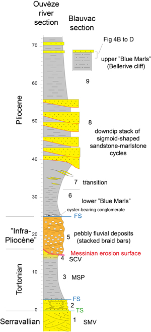
The incision of the riverbed south of
Roaix village and the continuous observations made downriver permit the
construction of a stratigraphic succession (Fig. 4 ).
Here, Pliocene deposits
infill the head of the Messinian valley where the Ouvèze carved Miocene deposits down to Tortonian
sandstone and marlstone formations (MSP and SMV, Fig. 4 ). The fluvial deposits
of unit 5 are a stack of pebbly lenses bearing metre-scale tabular oblique
stratification and which represent nested prograding braid bars. The occurrence
of a marine sandstone bed (unit 8, Fig. 4 ) in the middle of the Blue Marls
Formation is new, and is not seen in outcrops studied by Ballesio
(1972). This suggests it should onlap the Messinian slopes
at a greater depth. Its depositional features are reported in detail below. The
base of unit 8 is not sharp but transitional above what is informally called the
lower Blue Marls here, as some lenticular sandstone beds are found in the upper
part of unit 7. The thickness of unit 8 (between 10 and 15 m) is difficult to
estimate, given the prograding-aggrading way it crops out on riverbanks
downstream (see further illustrations). Unit 8 is overlain by the succession
cropping out in the Bellerive cliff (Fig. 2.A ), that is, the Blue Marls proper,
as found in the regional sections studied by Ballesio
(1972). Several sandstone beds are intercalated in the Blue
Marls upsection (Fig. 2.A ). Unlike the homogeneous, almost structureless
marlstone (Fig. 5.A ) intercalated between sandstone beds within unit 8, the
marlstone of the Bellerive cliff, especially its upper part where sandstone beds
occur again (Figs. 2.A , 4 ), is finely
laminated, made of a succession of event strata, millimetric to centimetric in
thickness, and interpreted as deposited
from surface, river-flood plumes within the ria. This facies is well exposed (Fig.
4.B-D ) behind the Trapadis wine cellar at Blauvac (location, Fig. 1 ),
better than in the Bellerive cliff. The laminated facies announces the
coarse-grained final infilling of the ria (e.g., the Coriançon section in Ballesio,
1972),
which is lacking here, due to Quaternary erosion.
|
|
Figure 4:
The sedimentary succession
logged along the banks of the Ouvèze
River, south of Roaix village. 1 to 9, stratigraphic units. Abbreviations: TS,
transgression surface; FS, flooding surface; MSP, Marnes de Saint-Pantaléon;
SCV, Sables du Château de Visan; SMV, Sables du Moulin à Vent. |
|
|
Figure 5:
View of the different kinds of
marlstone comprising the Blue Marls Formation. A, homogeneous marlstone within
unit 8; B-D, laminated silty marlstone at top of the formation, close to the
Trapadis wine cellar (Blauvac, location Fig. 1 |
Several examples of the depositional
geometry and internal features of unit 8 are illustrated, either at its base (Pl.
I ), or at its top
(Fig. 7 ) near
Saint-Aliman (location in Fig.
1.B ), and
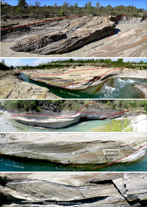
detailed further. The overall geometry of unit 8 is heterolithic, comprising a
lateral stack of gently inclined sandstone-dominated intervals, alternating with
marlstone-dominated ones (Pl.
I ,
fig. A). Because of their repetitive nature, these
couplets represent depositional cycles. The sandstone bodies have a sigmoidal
geometry. The marlstone cap is prograding-aggrading (draping) (Pl.
I ,
fig. A). Some
cycles are overall more sandstone-prone (upriver of Bellerive), others more
marlstone-prone (downriver of Bellerive). They are stacked downdip into a
generally prograding-aggrading pattern, although some cycles may be nested into
the previous one through a strong erosional surface (Pl.
I ,
figs. B-C). Some basal
surfaces may be deeply nested, such as to erode the marlstone-dominated upper
half-sequence of the previous sequence (Pl.
I ,
fig. B). This stacking pattern may be
continuously observed downriver to Saint-Aliman, where the last
sandstone-dominated cycles are found (Fig 6.A ). The cycles at
Saint-Aliman are
possibly the downdip part of an uppermost sandstone-dominated subpackage within
unit 8, linked to the sandstone bed observed at the base of Bellerive cliff (Fig.
2.B ). The stacking of cycles is regular in the downriver (that is,
downria)
direction, but there is some evidence of lateral shift (Pl.
I ,
fig. C).
|
|
Figure 6: A, view of the lateral stacking
of the uppermost three nested sandstone-marlstone sequences (1 to 3) close to
St. Aliman irrigation channel inlet, downriver. a, sandstone-dominated lower
part of sequences; b, marlstone-dominated upper part. Sequence 1 shows at least
three successive sandstone event beds in its lower part. Also note the low
elevation of terrace T2 (Fig. 2.D |
|
|
Figure 7:
Other features found in
sandstone beds (A- D, in the lower, sandstone-dominated part of sequences; E-F, in the marlstone-dominated upper part).
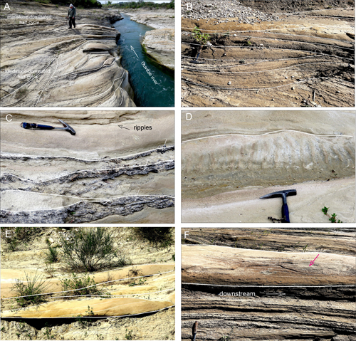
A-B, internal erosional
surfaces; C, shell hash veneers, sometimes with wood debris, atop of event beds;
D, preserved current ripples atop event beds; E, domal features with internal
sigmoidal lamination; F, complex lamination within a bed showing upcurrent
accretion (red arrow). |
The
sandstone-dominated half cycles comprise a stack of sandstone beds which are
event beds bounded by erosional surfaces. Marlstone intervals are few and thin.
The strongest erosional surfaces are within the lower part of the half-cycle (Fig.
7.A-B ;
Pl.
I ,
figs. D-E). The most common internal features are laterally-continuous
planar lamination or wavy lamination (Pl.
I ,
fig. D), the latter often showing
upstream accretion (Pl.
I ,
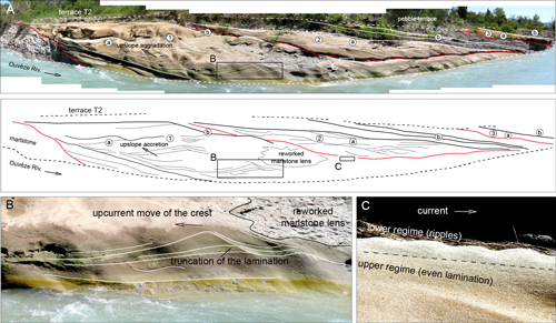
fig. E). The most prominent internal features found are
wavy bedforms whose crest on the steep stoss side is moving upstream while the
lamination on the gently inclined lee side is accreting upstream (Fig
6.B ).
Such features are characteristic of
cyclic steps occurring in high-velocity currents whose flow is marked by
hydraulic jumps. (e.g.,
Cartigny et al., 2011;
Slootman & Cartigny, 2020; Slootman et
al., 2021). All the observed depositional
features are therefore characteristic of supercritical currents with respect to
Froude number or at the boundary between super- and subcritical (planar
lamination).
When preserved from the erosion by the
next event bed, the top of the sandstone bed shows the transition from the upper
regime to the lower regime of the flow, represented by the passage from planar
lamination to ripples (Fig 6.C ). The ripples atop event beds are usually poorly
preserved due to the
nesting of erosional surfaces (Fig. 7.C-D ). They may look like nearly
symmetrical wave ripples but their internal lamination is oblique (Fig
6.C ),
indicating current ripples,
and not oscillation ripples.
Sandstone event beds may show at their
top either a veneer of oyster shell hash transported from a shallower area or
wood debris, or both (Fig. 7.C ). Wood debris occurs within just a single
sequence in the middle of the downriver stack, probably originating in large
forest fires that occurred in the hinterland.
In marlstone-dominated half-cycles,
scattered sandstone beds may be structureless, or show laterally continuous
planar lamination. In some cases, the tops of the beds are undulatory, forming
domes, in which the lamination is sigmoidal and prograding (Fig.
7.E ). Sandstone
beds may also occur as aligned metre-scale domes. No cyclic step features are
found, except for small-scale upcurrent accretion wtithin some sandstone beds (Fig.
7.F , red
arrow), probably indicating pulses in current speed during
deposition of the event bed.
Cyclic steps and antidunes are two kinds
of supercritical currents as defined by their Froude number. They may occur in
very different depositional environments from fluvial to deep marine (Slootmann
& Cartigny, 2020, Fig. 3). Cyclic steps
differ from antidune features by the occurrence of hydraulic jumps responsible
for regularly spaced overcuttings in the sand bed. They move slowly upstream and
are progressively sealed by aggrading to retrograding lamination on the lee side
of the bedforms (Slootmann & Cartigny,
2020,
Fig. 6). The observed features (Fig. 7.B ;
Pl.
I ,
figs. D- E) accord with this process. Within
stratigraphic unit 8, cyclic steps occur at the base of the sandstone-marlstone
cycles or sequences. Higher up in the sequences, only the wavy lamination of
antidunes and planar lamination are encountered in sandstone event beds.
Furthermore the frequency of sandstone beds diminishes in the upper part of the
cycles, judging by the increasing thickness of interstratified marlstone beds.
Such a change suggests that both discharge loads and overall velocity waned in
the course of the depositional cycle.
Rubino and Parize (2025) suggested that the sandstone-marlstone cycles in unit 8 could be equinoxial tidal cycles. However, we found no evidence of subcritical bedforms (dunes) attributable to tidal ebb currents but, rather, evidences of supercritical currents alone. In addition, although the depositional depth where marlstone interfingers with sandstone beds is difficult to estimate, the sequence stratigraphic context (see further discussion) supports a deep-water depositional environment. Thus, we conclude that unit 8 was deposited by river-flood-derived hyperpycnal bottom currents in a flooded ria.
The downriver stacking of
sandstone-marlstone sequences is illustrated schematically in Figure
8 . Some
cycles are strongly nested within the previous ones (Pl.
I ,
figs. B-C). This
situation is more prominent upriver at the base of unit 8. Conversely, some
cycles bear a well-developed marsltone-dominated half-cycle. This is more common
downriver. Nevertheless, cycles bearing cyclic steps are still encountered close
to the canal inlet of Saint-Aliman (Fig 6.A ) where the stratigraphic unit
disappears under recent alluvial deposits. According to observations made by one of us
(GT) in local
wine cellars carved in hill slopes, the contact between Pliocene and Miocene
deposits (as also shown in Fig. 3.B )
is
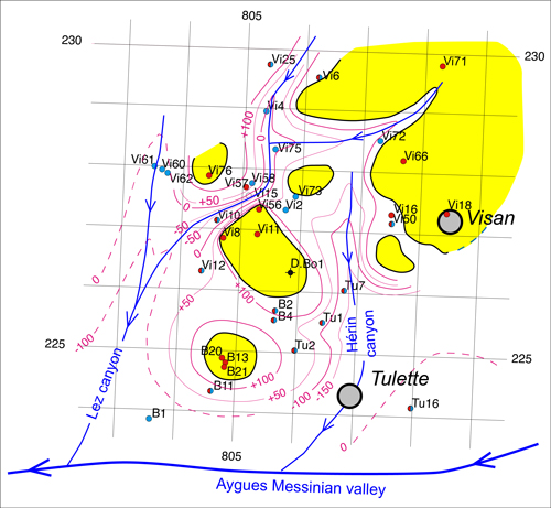
most often vertical or even overhanging. The water-wells data base of
Geoapplication Co. (GT) around the village of Visan also shows (Fig.
9 ) that the
Messinian morphology of the Comtat basin was probably the result of castellated
erosion, given its similarity to Bryce Canyon on the Colorado
Plateau of Utah. These observations suggest that the stacking of hyperpycnal
sequences in the Ouvèze
ria was strictly constrained in the downstream direction, that is, with limited
lateral shifting (Pl.
I ,
fig. C) in a compensational mode, due to the likely
narrowness of the ria bottom, as supported by the morphological reconstruction
of Do Couto et
al. (2024).
|
|
Figure 8:
Sedimentary model proposed for
unit 8. |
|
|
Figure 9:
Reconstruction of the castellated Messinian morphology based on
water-well data from the private Geoapplication data base (owner Georges Truc)
collected around Visan village. Red contour lines of the Miocene-Pliocene
contact are absolute elevation versus sea level. Yellow for
outcropping Mocene sandstone (absolute elevations west of Visan village are
between 100 and 130 m). For instance, the bottom of the Herein canyon beneath
Tulette village is at a depth of more than 350 m. Location of the Messinian
Aygues River course, see Fig. 1 |
In the middle of the prograding stack, a
layer of unbroken oysters seals a gently-inclined surface truncating a sequence
down to its sandstone lower half (Fig. 10.A ).
The truncation surface cuts the sandstone updip (Fig. 10.C ), and the marlstone
of the sequence downdip (Fig. 10.D, I ). Because the oysters are in life position
and tightly packed (Fig. 10.B ), this bed has a different origin from that of the
oyster shell hash veneers found within the sandstone-marlstone sequences (Fig.
7.C ), which are clearly transported from an upstream location. Detailed
observations show that the oyster layer is associated with intense bioturbation
of the underlying sandstone (Fig. 10.E ). Such bioturbation is not observed in
other sandstone-marlstone sequences of unit 8. The base of the oyster bed also
shows aligned hollows carved into
the bioturbated sandstone, possibly due to some kind of bioturbation (Fig.
10.E ). The sandstone beds may bear comminuted debris of oysters and, more
commonly, shells of the Lucines group (Loripes
sp.) within the beds, probably due to their greater buoyancy (Fig.
10.H ). These
were reworked from shallower environments updip, and broken during their
transport by the powerful hyperpycnal flows. The small hollows cut into the
bioturbated top of the truncated sequence (Fig. 10.E ) host venerid bivalves (Pelecyora
sp.) (Fig. 10.F ) that are known to thrive in very shallow-water sands or sandy
clays (intertidal zone in open seas). They are overlain by the bed of stacked
oysters but may also be associated with them (Fig. 10.G ). This undisturbed fauna
is clear evidence that the oyster bed that truncates the sandstone-marlstone
sequence (Fig. 10 ) was emplaced close to sea level, in sharp contrast with the
underlying sandstone
beds deposited at a greater depth. It therefore represents a marked fall in
relative sea level during the deposition of the Blue Marls Formation. The
interpretation is that a first package of deep-water cycles was exposed,
truncated, and then reflooded, the oyster bed representing the first stage of
the transgression.
|
|
Figure 10:
Oyster bed sealing a
truncation surface in the middle of the sequence stack. A, general view of the
truncation; B, close view of the oyster bed; C, close view of the truncation
surface underneath the oyster bed; D, view of the oyster bed resting on
marlstone downdip; E, bowls cut into the bioturbated top of the sandstone prism;
F, view of a venerid bivalve within a bowl; G, venerid vivalves associated with
oysters in the oyster bed; H, broken, thin-shelled lucinid bivalves within the
hyperpycnal sandstone beds; I, cartoon summarising all observations. |
From the data acquired in the lower Cèze
tributary of the Rhône river (Ferry et al., 1997a), the bottom of the Rhône ria at the confluence with
the Ouvèze
river would be at a depth around 600-650 m below the surface. According to
paleogeographic reconstructions (Ballesio, 1972; Do Couto et
al., 2024) the confluence of the Messinian
Ouvèze
river was close to that of the Cèze river. The distance from the confluence to
the outcrops of the middle Cèze
river is short (Fig. 1 ).
So, the slope of the Messinian Ouvèze
valley was particularly steep, even taking into account a Quaternary peri-Alpine
uplift likely to have steepened the ria profile updip. Therefore, it is likely
that Pliocene flood events entered the ria directly as hyperpycnal bottom
currents, shunting possible narrow deltas whose deposits may have been fully
reworked by megafloods.
The significance of the whole shingled package of sandstone-marlstone cycles of unit 8 within the Blue Marls is difficult to interpret. Although emplaced by deep hyperpycnal bottom currents as discussed above, is it linked to a sea-level fall during the fully flooded stage of the ria, that is, to a closer injection point of river floods in the ria? The upper reaches of the ria are not known because they are now eroded, precluding investigation of the updip extension of the sedimentary body. Also are the sandstone-marlstone sequences within the package the expression of changes in relative sea level, as for the whole package? The more "distal" character of the upper deposits within a sandstone-marlstone sequence could either reflect a climate-controlled declining intensity of flood events with time, or be the result of down- and upria moves of the injection point of river floods. This remains therefore an open question. The occurrence of the very shallow oyster bed within the prograding stack, as well as its characteristics, are nevertheless evidence that strong relative sea-level falls may occur during the fully flooded stage of the ria. Such fluctuations in sea level have been evidenced in some places (Clauzon et al., 2015; Dromart et al., 2024).
In his latest work on turbidite systems
and the disputed turbidite paradigm, E. Mutti
(2023) highlighted the connection between river floods and turbidites via
hyperpycnal subaqueous flood currents (hyperpycnites) instead of resulting from
gravitational slope collapses. The data acquired in the middle Ouvèze
river suggest that there could be a continuum of transport mechanisms between
the depositional features observed in the sandstone-marlstone half-cycles.
Sedimentary features found in sandstone event beds may indeed appear "proximal"
in the sandstone-dominated half-cycle, and "distal" in the
marlstone-dominated half-cycle. In other words, it is suggested that the
sandstone event beds may have a proximal facies bearing cyclic steps, and a
distal facies featuring mostly planar lamination, which is similar to turbidite
beds. Unfortunately, the limited outcrops along the Ouvèze river banks (Pl.
I ) prevent observation of
the bottomsets of the sandstone-dominated half-cycles. The Pliocene succession
of the Cèze
river ria (especially the finely-laminated marlstone to siltstone observed
behind the Trapadis wine cellar; Figs. 4 ,
5.A ) is an excellent
illustration of the two kinds of river-flood beds deposited in a proximal marine
environment: hyperpycnites at base, and "plumites" (Mutti,
2023) at the top of the succession. The latter correspond to
dilute river flood plumes laid down through a pure settling process, instead of
the high-density bottom currents responsible for the former.
The exploration works carried out by
Andra in the 1990s in the Cèze
River basin close to the Marcoule nuclear site comprised a number of deep, fully
cored wells and seismic profiles. They permitted correct replacement of the
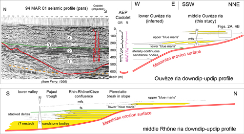
Codolet water well (Fig. 11 ) within the seismic imaging
(Fig. 12
- upper left).
The stack of sandstone beds at the base of the well was previously assigned a
Cenomanian age until the seismic profiles showed they are in fact the base of
the Pliocene ria infilling. The Pliocene succession (Fig. 12
- upper left)
comprises a poorly imaged succession, probably sandy, at the base, overlain by a
stack of laterally continuous reflectors corresponding to the sandstone aquifers
found at base of the Codolet well, and finally the classical Pliocene Blue Marls
of the Rhône valley network at the top. The lower part of the Blue Marls shows
inclined reflectors (lined in white in Fig. 12
- upper left) suggesting the
occurrence of a prograding body.
|
|
Figure 11:
The Codolet water well
(location on Fig. 1 |
|
|
Figure 12:
Relation of the data from the
Ouvèze
ria to those acquired once in the Cèze
ria (location in Fig. 1 |
Subsequent investigations downria in the
Pujaut trough (Ferry et
al., 1997a) showed that the base of the
Pliocene infilling comprises nested sandstone-marlstone sequences likely to be
correlated with the very base of the Pliocene succession in the Andra seismic
profile 94 MAR 01 (Fig. 12 ). The nesting of the basal sequences suggests a
complex depositional geometry which would explain the lack of continuous
reflectors at base of the Andra profile.
Despite the lack of cores (and thus of
interpretable sedimentary features) in the Codolet aquifers, it is unlikely that
the continous reflectors could be mass transport deposits (MTDs) in a fully
flooded ria, as concluded by Do Couto et al. (2024). We
suggest instead that the lower half of the Pliocene infilling represents a stack
of deltaic sequences encroaching (Fig. 12
- bottom) on the break in slope south
of Pierrelatte (Clauzon, 1982, Fig. 4). The
Andra seismic profile is oriented N-S close to the confluence of the Cèze
and Rhône rivers. If the interpretation of stacked delta sequences is correct,
the main delta was the Rhône
River's, but that it also filled the mouth of the
tributaries which were at the same relative sea level. The sandstone stack
should therefore onlap the Messinian slope in the Ouvèze ria (Fig.
12
- upper right). Consequently,
the prograding sandstone body newly found in the Ouvèze
River is correlated with the equivalent prograding unit in the 94 MAR 01 profile
(Fig. 12
- upper left). According to this interpretation, the infilling of the
ria network would comprise a very thick sandstone-dominated transgressive tract
marked by a number of relative sea-level oscillations responsible for the
sandstone-marlstone alternation in the Codolet well. The top of this
transgressive tract would be the real flooding surface (Fig.
12
- upper left and
bottom). The prograding bed of the middle Ouvèze
river banks is not part of the delta stack but an uncommon subaqueous body
deposited on the slope within the late flooding stage. The homogeneous marlstone
facies (Fig. 5.A ) found within this body is deeper than that of the Bellerive
cliff because it lacks any evidence of river-plume deposition (Figs. 2.A ,
5.B ,
12
- upper right) which represents the beginning of the final infilling of the ria. The maximum flooding surface in the system is therefore placed just above
the newly found sedimentary body (Fig. 12
- upper right). These data therefore challenge the commonly held interpretation of a
sudden and full reflooding of the desiccated Mediterranean basin (Zanclean
Deluge), in favor of a progressive, likely stepped flooding of the Messinian
subaerial valleys.
Consequently, the question arises as to why the infilling of short Mediterranean rias does not feature such a sandstone transgressive tract, which has popularized the "Deluge" interpretation? A possible explanation is that the Rhône River cannot reasonably be compared to the short Mediterranean coastal rivers with respect to both their catchment areas and geology. Moreover, in the early late Pliocene, the Rhine River flowed for some time to the south, through the valleys of the Doubs and Saône rivers in eastern France (Petit et al., 1996; Giamboni et al., 2004). In addition, the upper Rhône River at that time flowed across the Helvetic Molasse basin before merging with the Rhine river (Madritsch et al., 2010). As a consequence, when the Rhine-Rhône river reached the modern middle Rhône valley, it carried a huge sandy bedload which was not entirely deposited within the subsiding Bresse-Dombes basin, north of Lyon city. The Rhine River course then changed to the north about 3 Ma ago (Giamboni et al., 2004), which is roughly coincident with the beginning of the incision of the fluvial network in the uplifted peri-Alpine domain of eastern France. The fact that the Pliocene Rhine-Rhône river was for some time a powerful sand-bed river is shown by the huge prodeltaic clinoforms cropping out in the Domazan area (Pujaut trough) and the deltaic cross-bedded sandstones of Saint-Laurent-des-Arbres a little updip (Ferry et al., 1997a).
The occurrence of the exposure surface within the stack of sequences (Fig. 10) is difficult to explain because it requires a marked fall in relative sea level in the ria, notwithstanding the imprecision regarding the depositional depth of the blue marls.
Pliocene oxygen isotope curves derived from marine benthics show that a brief cold snap occurred in the Zanclean around 3.2 Ma (Lisiecki and Raymo, 2005). Evidence of a coeval climatic shift is also known on land (e.g., Amarathunga et al., 2024; Czwakiel et al., 2025). Are the tectonically driven changes of river courses evoked above around 3 Ma associated with this cold snap ? Was a glacial drop in sea level strong enough to expose the hyperpycnal unit 8, if really coeval with the other data ? Fully answering these questions requires additional data (cores, seismic profiles, age dating) to integrate the local observations into the whole corpus of data of the Mediterranean reflooding.
A local 5 to 9 m recent overdeepening of the Ouvèze riverbed south of Roaix village exposed an unexpected, distinctive sandstone marine bed at the base of the Pliocene Blue Marls which filled a flooded Messinian canyon at the end of the MSC. This bed is a prograding-aggrading stack of sandstone-marlstone cycles deposited at some depth by hyperpycnal bottom currents linked to flood events updip. The layer is integrated into the larger context of the middle Rhône valley network, especially with the discoveries made during the Andra works in the 1990s at the confluence of the Rhone and Cèze rivers. The data cast doubts upon the reality of the so-called Zanclean Deluge, or abrupt reflooding of the Messinian canyons. The existence of a thick sandy transgressive tract comprising a large number of stacked deltaic sequences onlapping the break in slope south of Pierrelatte, and likely to also occur in tributaries (Cèze, Aygues and Ouvèze rias), is suggested. The reflooding of the Mediterranean basin was therefore progressive, interrupted by small drops and/or pauses, leading to a series of updip jumps of the shoreline in the rias, especially in the first stage of reflooding. These oscillations in relative sea level also occurred within the upper part of the ria infilling (Blue Marls) which represent the final reflooding of the Rhône river system.
The study being made by geologists now retired, field work was undertaken with personal financial resources.
Special thanks to Helen Durand, owner of the Trapadis wine cellar, Blauvac hamlet, who allowed access for studying the spectacular outcrop of laminated Blue Marls deposits behind the cellar. Comments by the two reviewers (J.-P. Suc, Université Paris Sorbonne, and J.-Y. Reynaud, Université de Lille) helped to improve the manuscript.
Amarathunga U., Rohling E.J., Grant K.M., Francke A., Latimer J., Klaebe R.M., Heslop D., Roberts A.P. & Hutchinson D.K. (2025).- Mid-Pliocene glaciation preceded by a 0.5-million-year North African humid period.- Nature Geoscience, vol. 17, no. 7, p. 660-666.
Bache F., Popescu S.-M., Rabineau M., Gorini C., Suc J.-P., Clauzon G., Olivet J.-L., Rubino J.-L., Melinte-Dobrinescu M.C., Estrada F., Londeix L., Armijo R., Meyer B., Jolivet L., Jouannic G., Leroux E., Aslanian D., Tadeu Dos Reis A., Mocochain L., Dumurdzanov N., Zagorchev I., Sokoutis V.D., Csato I., Icarkus G. & Cakir Z. (2012).- A two-step process for the reflooding of the Mediterranean after the Messinian salinity crisis.- Basin Research, vol. 24, p. 125-153. URL: https://archimer.ifremer.fr/doc/00076/18774/
Ballesio R. (1972).- Étude stratigraphique du Pliocène rhodanien.- Travaux et Documents des Laboratoires de Géologie de Lyon, no. 53, 334 p. URL: https://www.persee.fr/doc/geoly_0076-1672_1972_mon_53_1
Cartigny M.J.B., Postma G., Berg J.H. van den & Mastbegen D.R. (2011).- A comparative study of sediment waves and cyclic steps based on geometries, internal structures and numerical modeling.- Marine Geology, vol. 280, p. 40-56. DOI: 10.1016/j.margeo.2010.11.006
Clauzon G. (1979).- Le canyon messinien de la Durance (Provence, France) : Une preuve paléogéographique du bassin profond de dessiccation (The Messinian Durance Canyon (Provence, France): Palaeogeographic evidence for a desiccated deep basin.- Palæogeography, Palæoclimatology, Palæoecology, vol. 29, p. 15-40.
Clauzon G. (1982).- Le canyon messinien du Rhône : Une preuve décisive du "desiccated deep-basin model" [Hsü, Cita & Ryan, 1973].- Bulletin de la Société Géologique de France (série 7), Paris, t. XXIV, no. 3, p. 597-610.
Clauzon G. & Rubino J.-L. (1992).- Les Gilbert deltas pliocènes du Golfe du Lion et de Ligurie : Des constructions sédimentaires originales consécutives à la crise de salinité messinienne.- Livret guide de l'excursion ASF, 127 p.
Clauzon G., Suc J.-P., Gauthier F., Berger A. & Loutre M.-F. (1996).- Alternate interpretation of the Messinian salinity crisis: Controversy resolved?- Geology, Boulder - CO, vol. 24, no. 4, p. 363-366.
Clauzon G., Suc J.-P., Do Couto D., Jouannic G., Melinte-Dobrinescu M.C., Jolivet L., Quillevéré F., Lebret N., Mocochain L., Popescu S.-M., Martinell J., Domenech R., Rubino J.-L., Gumiaux C., Warny S., Bellas S.M., Gorini C., Bache F., Rabineau M. & Estrada F. (2015).- New insights on the Sorbas Basin (SE Spain): The onshore reference of the Messinian Salinity Crisis.- Marine and Petroleum Geology, vol. 66, part 1, p. 71-100. DOI: 10.1016/j.marpetgeo.2015.02.016
Czwakiel N., Gallagher T., Serach L., Ludvigson G., Suc J.-P., Da J. & Breecker D.O. (2025).- The Onset of summer drought on the Iberian Peninsula following Pliocene global cooling.- Paleoceanography and Paleoclimatology, vol. 40, article e2025PA005121, 20 p. DOI: 10.1029/2025PA005121
Do Couto D., Cushing E.M., Mocochain L., Rubino J.-L., Miquelis F., Hanot F., Froment B., Gélis C., Camus H., Bagayoko N. & Bellier O. (2024).- Messinian canyons morphology of the Rhône and Ardèche rivers (south-east France): New insights from seismic profiles.- BSGF - Earth Sciences Bulletin 2024, vol. 195, article 19, 23 p. DOI: 10.1051/bsgf/2024015
Dromart G., Suc J.-P., Popescu S.-P. & Rubino J.-L. (2024).- The Pliocene succession of Lyon Metropolis (SE France): An overfill of a Messinian incised-valley.- BSGF - Earth Sciences Bulletin 2024, vol. 195, article 6, 23 p. DOI: 10.1051/bsgf/2024006
Ferry S., Ballesio R. & Monier P. (1997a).- Modalités du remplissage sédimentaire de la ria pliocène du Rhône. Problèmes en suspens après les premiers travaux Andra.- Actes des Journées scientifiques ANDRA, Bagnols/Cèze (20-21 octobre 1997), Volume Posters, Andra édit. URL: https://hal.science/hal-05302586v1
Ferry S., Brulhet J. & Monier P. (1997b).- Le remplissage complexe de la ria pliocène du Rhône et ses implications.- 6e Congrès français de Sédimentologie, Montpellier, Publication ASF, no. 27, p. 117 (abstract). URL: https://hal.science/hal-05302588v1
Ferry S., Grosheny D. & Amédro F. (2022).- Sedimentary record of the "Austrian" tectonic pulse around the Aptian-Albian boundary in SE France, and abroad.- C.R. Geoscience, vol. 354, p. 67-87. DOI: 10.5802/crgeos.121
Giamboni M., Wetzel A., Nivière B. & Schumacher M. (2004).- Plio-Pleistocene folding in the southern Rhinegraben recorded by the evolution of the drainage network (Sundgau area; northwestern Switzerland and France).- Eclogae geologicae Helvetiae, Basel, vol. 97, p. 17-31. URL: https://sjg.pensoft.net/article/35700/
Hsü K.J., Ryan W.B.F. & Cita M.B. (1973).- Late Miocene desiccation of the Mediterranean.- Nature, vol. 242, p. 240-244.
Lisiecki L.E. & Raymo M.E. (2005).- A Pliocene-Pleistocene stack of 57 globally distributed δ 18 O records.- Paleoceanography, vol. 20, no. 1, article PA1003, 17 p. DOI: 10.1029/2004PA001071
Madritsch H., Fabri O., Hagedorn E.-M., Preusser F., Schmid S.M. & Ziegler P.A. (2010).- Feedback between erosion and active deformation geomorphic constraints from the frontal Jura fold-and-thrust belt (eastern France).- International Journal of Earth Sciences (Geologische Rundschau), vol. 99, p. 103-122.
Meijer P.Th. & Krijgsman W. (2005).- A quantitative analysis of the desiccation and re-filling of the Mediterranean during the Messinian salinity crisis.- Earth and Planetary Science Letters, vol. 240, no. 2, p. 510-520.
Monier P., Chalmin P., Ferry S., Truc G., Quaile J., Curial A., Moretto R. & Russo R. (1998).- Cartographie géologique régionale, reconstitution géométrique et paléogéographique de la cuvette comtadine.- 17e Réunion des Sciences de la Terre, Brest (31 mars - 3 avril 1998), Livre des résumés, p. 162 (abstract).
Mutti E. (2023).- Turbidite systems: An outcrop-based analysis.- PETROBRAS, Rio de Janeiro, 466 p. URL: https://publicacoesup.petrobras.com.br/peld/catalog/book/5
Petit C., Campy M., Chaline J. & Bonvalot J. (1996).- Major palaeohydrographic changes in Alpine foreland during the Pliocene-Pleistocene.- Boreas, vol. 25, no. 2, p. 131-143.
Popescu S.M., Cavazza W., Suc J.-P., Melinte-Dobrinescu M.C., Barhoun N. & Gorini C. (2021).- Pre-Zanclean end of the Messinian salinity crisis: New evidence from central Mediterranean reference sections.- Journal of the Geological Society, London, vol. 178, no 3, article, 16 p.
Rubino J.-L. & Parize O. (2025).- Transgressive-regressive cycle within the Messino-Pliocene infill of the Ouvèze ria, SE France.- 29e Réunion des Sciences de la Terre, Montpellier (27-31 octobre 2025), Abstract Book, p. 565 (abstract).
Slootman A. & Cartigny M.J.B. (2020).- Cyclic steps: Review and aggradation-based classification.- Earth-Science Reviews, vol. 201, article 102949, 30 p.
Slootman A., Ventra D., Cartigny M.J.B., Normandeau A. & Hubbard S. (2021).- Supercritical-flow processes and depositional products: Introduction to thematic issue.- Sedimentology, vol. 68, no. 4, p. 1289-1296.
Suc J.-P., Rubino J.-L., Popescu S.-P., Melinte-Dobrinescu M.C., Barhoun N., Dromart G., Do Couto D., Leroux E., Pellen R., Gorini C., Bache F., Çağatay M.N., Jolivet L., Mocochain L., Hippolyte J.-C., Rabineau M., Loget N., Meyer B., Gargani J., Karakaş Ç., Aslanian D. & Chirol B. (2026).- The two-step scenario of the Messinian Crisis (Clauzon et al., 1996): A specification supported by new data.- BSGF - Earth Sciences Bulletin, vol. 197, Paris, article 2, 24 p. DOI: 10.1051/bsgf/2025021
|
Plate I:
Views of the inclined
heterolithic stratification within unit 8 in the Ouvèze River banks. A, typical organisation of
sandstone-dominated to marlstone-dominated packages forming laterally accreting
sequences (red lines, sequence boundaries); B, stacking of more or less nested
successive sequences; C, stacked sequences showing changes in the direction of
progradation (white arrows); D, wavy stratification (cyclic steps) at base of a
sequence; E, detail showing upstream accretion. |
|