◄ Carnets Geol. 26 (8) ►
![]()
Outline:
[1. Introduction]
[2. Field data]
[3. Age of sequences]
[4. Stratigraphic comparison with the Esparron-Esclangon area]
[5. Paleogeographies]
[6. Conclusions]
and ...
[Bibliographic references]
corresponding author
6D Avenue Général de Gaulle, 05100 Briançon (France)
Université de Lyon (retired)
Université Lyon 1, UCBL, ENSL, UJM, CNRS, LGL-TPE, Villeurbanne (France)
Published online in final form (pdf) on May 21, 2026
DOI 10.2110/carnets.2026.2608
![]()
[Editor: Bruno
R.C. Granier; language editor: Robert W. Scott]
![]()
The SW-NE-trending Faucon-du-Caire/Turriers tectonic corridor hosts a thick Paleogene Molasse Rouge s.l. succession that shows similarities to the same interval found in the nearby Esparron syncline. In each setting, the succession is composed of three superposed sequences designated S1, S2 and S3 from bottom to top respectively (Ferry et al., 2025). Although similar in internal character, they vary in thickness between the two localities with respect to both complete sequences and subunits. Sequence S1 represents the western shore of a continental basin oriented to the Alpine Mountain Belt. Deposits of sequence S2 (Molasse Rouge 1, or MR1) are confined to a valley that forms a westward continuation of the Esparron syncline, terminating against the Grand Vallon fault, which caused a shift of the river to the southwest where its exits the Digne transported basin. Downstream, its course likely followed the front of the Ventoux-Lure thrust. Deposits of sequence S3 (Molasse Rouge 2, or MR2) are up to 500 m thick in the Faucon-du-Caire/Turriers area, comprising a lower pebbly facies, around 200 m thick, that was formed by a braided fluvial system. This is overlain by reddish sandstone-dominated alluvial fan deposits approximately 300 m thick. Sequence S3 appears to be mostly constrained to the Faucon-Turriers corridor. Its materials were transported to the SW, exiting the Digne nappe along the front of the Ventoux-Lure thrust. This path is better documented than that of MR1. A first major point is confirmation that a major change in paleocurrent orientation occurred around the Rupelian-Chattian transition, with the deposits of upper Rupelian sequence S1 being oriented to the Alps, and those of the Chattian sequences S2 and S3 oriented the opposite direction to the west. A second point is that strong tectonic deformation occurred between the deposition of MR1 and MR2.
• molasse;
• Rupelian;
• Chattian;
• Alps;
• France
Ferry S., Sorrel Ph., Grandjean Ph. & Augier S. (2026).- The peri-Alpine Paleogene Red Molasse of southeastern France - II. Faucon-du-Caire/Turriers area (Alpes-de-Haute-Provence).- Carnets Geol., Madrid, vol. 26, no. 8, p. 163-176. DOI: 10.2110/carnets.2026.2608
Les molasses rouges paleogčnes péri-alpines du Sud-Est de la France - II. Secteur de Faucon-du-Caire/Turriers (Alpes-de-Haute-Provence).- Le couloir tectonique de Faucon-du-Caire/Turriers comporte une épaisse succession Paleogčne de Molasse Rouge qui présente des similitudes avec celle réanalysée dans le secteur plus méridional d'Esparron-Esclangon (Ferry et al., 2025). La série est composée des męmes trois séquences superposées, nommées S1, S2 et S3, de la base au sommet. Elles varient cependant en épaisseurs et facičs de dépôt pour chacune des unités qui les composent. Les dépôts de la séquence S1, d'âge probablement rupélien supérieur, représentent la bande de facičs torrentiel bordant un bassin ŕ polarité orientée vers les Alpes, au contraire de ceux des deux suivantes, d'âge chattien, qui ont l'orientation inverse, vers l'extérieur de la chaine. Les dépôts de la séquence S2 (ou Molasse Rouge 1, MR1) remplissent une paléovallée qui est la continuation vers l'ouest de la paléovallée synclinale d'Esparron. Mais le trajet est dévié contre la faille du Grand Vallon pour sortir du bassin transporté de Digne vers le SW, et suivre vraisemblablement le front du chevauchement Ventoux-Lure. Les dépôts de la séquence 3 (ou Molasse Rouge2, MR2) ont une épaisseur totale d'environ 500 m dans le couloir de Faucon-Turriers. Ils comportent un facičs fluviatile conglomératique en tresses ŕ la base (épaisseur 200 m) surmonté par les dépôts rouges d'un cône alluvial sablo-argileux (environ 300 m). Le sens d'écoulement de ces deux unités est vers le SW, suivant exactement l'orientation du couloir tectonique. Il existe pour cette séquence S3 des données sédimentaires robustes supportant l'idée d'un exutoire longeant le front Ventoux-Lure. Les données acquises confirment donc un changement de polarité sédimentaire au passage Rupélien-Chattien, ainsi que des déformations tectoniques intra-chattiennes qui modifient fortement les reliefs et donc les dépôts-centres de la séquence S2 ŕ la séquence S3.
•
molasse ;
• Rupélien ;
• Chattien ;
• Alpes ;
• France
This
study is the continuation of the revision of Oligocene deposits in front of the
southern French Alps, which were grouped for a long time under the catch-all
term of "Molasses Rouges" in the French literature. In a previous paper
(Ferry et al., 2025), we revised these units in the central external part of the
Digne nappe (Fig. 1.A ![]() ), especially the Esparron and Esclangon synclines (resp.
ESP and ESC, Fig. 1.A
), especially the Esparron and Esclangon synclines (resp.
ESP and ESC, Fig. 1.A ![]() ) due to their spectacular and laterally continuous
outcrops. The Molasse Rouge successions (Fig. 2
) due to their spectacular and laterally continuous
outcrops. The Molasse Rouge successions (Fig. 2 ![]() ) were subdivided there into
three unconformity-bounded continental sedimentary successions, named sequences
S1, S2 and S3. Sequence S1 is mostly represented by torrential breccia fans
(basal unit BU) whose deposits were often considered as a mere basal facies of
the MR. Our revision suggested, instead, that they could represent a fully
independent foreland sequence, but, which needed a broader regional survey to be
fully recognized as such. Sequences S2 and S3 cover the most part of MR
deposits.
Our work showed that the depot-centres of sequences S2 and S3 shifted over time,
due to intervening tectonic deformation. Also, fluvial depositional facies are
different, supporting the need to split the thick MR deposits above the basal
breccia (S1) into MR1 (S2) and MR2 (S3). Current direction in S1 deposits are to
the east, those of MR1 and MR2 are to the west and contain inner Alpine
material,
contrarily to those of S1. The discussed age of the three sequences is likely
latest Rupelian for S1 (to be confirmed after a broader regional study), and
Chattian for S2 (MR1) and S3 (MR2). Both the MR1 and the MR2 bear low-sloped
fluvial deposits at base (meandering for MR1 and braided pebbly for MR2). These
basal deposits are overlain by large alluvial fan deposits in both sequences,
which are, therefore, judged to record relief changes during their deposition.
) were subdivided there into
three unconformity-bounded continental sedimentary successions, named sequences
S1, S2 and S3. Sequence S1 is mostly represented by torrential breccia fans
(basal unit BU) whose deposits were often considered as a mere basal facies of
the MR. Our revision suggested, instead, that they could represent a fully
independent foreland sequence, but, which needed a broader regional survey to be
fully recognized as such. Sequences S2 and S3 cover the most part of MR
deposits.
Our work showed that the depot-centres of sequences S2 and S3 shifted over time,
due to intervening tectonic deformation. Also, fluvial depositional facies are
different, supporting the need to split the thick MR deposits above the basal
breccia (S1) into MR1 (S2) and MR2 (S3). Current direction in S1 deposits are to
the east, those of MR1 and MR2 are to the west and contain inner Alpine
material,
contrarily to those of S1. The discussed age of the three sequences is likely
latest Rupelian for S1 (to be confirmed after a broader regional study), and
Chattian for S2 (MR1) and S3 (MR2). Both the MR1 and the MR2 bear low-sloped
fluvial deposits at base (meandering for MR1 and braided pebbly for MR2). These
basal deposits are overlain by large alluvial fan deposits in both sequences,
which are, therefore, judged to record relief changes during their deposition.
|
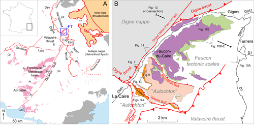
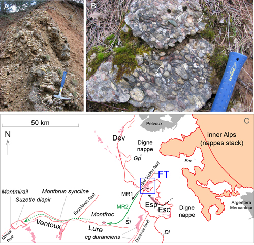
Figure 1:
Location maps. A, outcrops of Oligocene peri-Alpine continental deposits in
SE France (in pink), dark-grey: Paleozoic basement including Permian sedimentary
rocks and volcanics. B, map of the
three continental sequences in the Faucon-Turriers corridor bounded by the Grand
Vallon fault (orange, sequence 1; pink, sequence 2 or Molasse Rouge 1 [MR1];
violine, sequence 3 or Molasse Rouge 2 [MR2]), green, Calcaire Nummulitique and
Marnes Bleues; white, undifferentiated Mesozoic deposits). Tectonic units named
in grey italics after Gidon (1997), as well as fault names. Abbreviations: Ap,
Apt; Ax, Aix; Ba, Barręme, Cp, Carpentras; Dev, Dévoluy; Di, Digne; ESC,
Esclangon; ESP, Esparron; Fo, Forcalquier; FT, Faucon-Turriers; Ga, Gap; Ma,
Manosque; Mrs, Marseille; Si, Sisteron; Va, Valensole. |
|
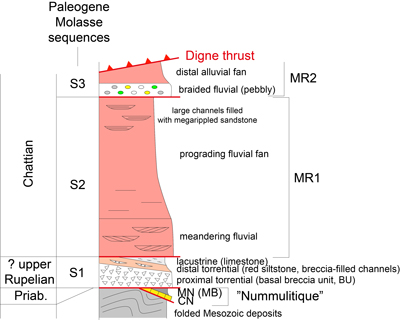
Figure 2:
Paleogene depositional sequences recognized in the Esparron-Esclangon area
(Ferry et al., 2025). Without scale. CN, Calcaire Nummulitique; BM, Blue Marls
or Marnes Nummulitiques, Priab., Priabonian. |
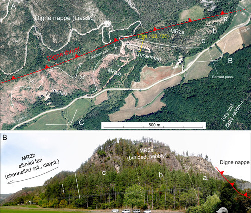
The
present study focusses on an elongated area (FT, Fig. 1.A ![]() ) that is particularly
tectonically complex on the frontal part of the Digne thrust (Arnaud et al.,
1977; Gidon, 1997). According to Gidon
(1997), what we call here the
Faucon-Turriers (FT) corridor based on sedimentologic data discussed further is
not included in the Digne Nappe (Fig. 1.B
) that is particularly
tectonically complex on the frontal part of the Digne thrust (Arnaud et al.,
1977; Gidon, 1997). According to Gidon
(1997), what we call here the
Faucon-Turriers (FT) corridor based on sedimentologic data discussed further is
not included in the Digne Nappe (Fig. 1.B ![]() ). Its sole is uplifted by the Grand
Vallon (or Faucon) fault (Fig. 1.B
). Its sole is uplifted by the Grand
Vallon (or Faucon) fault (Fig. 1.B ![]() ), therefore, revealing a half window
corresponding to the corridor. A succession of thrusts to the SW occur within
this half window, from the Faucon tectonic scales (units not represented on Fig. 1.B
), therefore, revealing a half window
corresponding to the corridor. A succession of thrusts to the SW occur within
this half window, from the Faucon tectonic scales (units not represented on Fig. 1.B ![]() for clarity) to the units south of the W-E inverse fault of the Bouchouse
ravine (Fig. 1.B
for clarity) to the units south of the W-E inverse fault of the Bouchouse
ravine (Fig. 1.B ![]() ). These units were formerly included in the Valavoire thrust (Gidon
& Pairis, 1992), but considered later (Gidon,
1997) as autochtonous.
). These units were formerly included in the Valavoire thrust (Gidon
& Pairis, 1992), but considered later (Gidon,
1997) as autochtonous.
As
in the Esparron-Esclangon area to the south (Fig. 1.A ![]() ), three continental
depositional sequences are recognized and mapped in orange, pink and violet
colours, in stratigraphic order (Fig. 1.B
), three continental
depositional sequences are recognized and mapped in orange, pink and violet
colours, in stratigraphic order (Fig. 1.B ![]() ). Unlike in the Esparron-Esclangon
area, the Molasse deposits rest to the NE on marine "Nummulitic" successions
(Calcaire Nummulitique and Marnes Bleues) (Fig. 1.B
). Unlike in the Esparron-Esclangon
area, the Molasse deposits rest to the NE on marine "Nummulitic" successions
(Calcaire Nummulitique and Marnes Bleues) (Fig. 1.B ![]() ). The upper,
sandstone-dominated part, of the marine succession, or Grčs d'Annot, is
lacking here, either being non-deposited or eroded before the deposition of the
Molasse sequences.
). The upper,
sandstone-dominated part, of the marine succession, or Grčs d'Annot, is
lacking here, either being non-deposited or eroded before the deposition of the
Molasse sequences.
Due to difficult accessible steep slopes and a more or less dense vegetation cover, most sections were estimated from picture panoramas, and the geometry of deposits imaged through a drone survey.
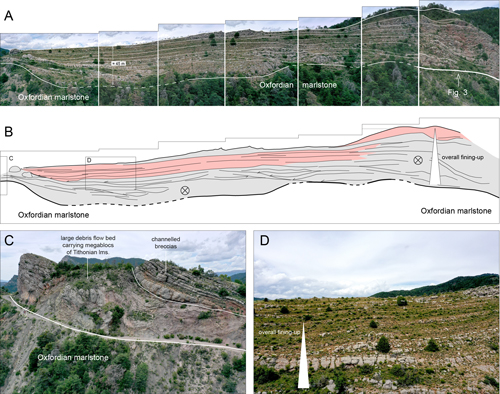
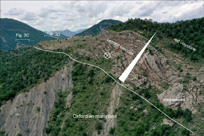
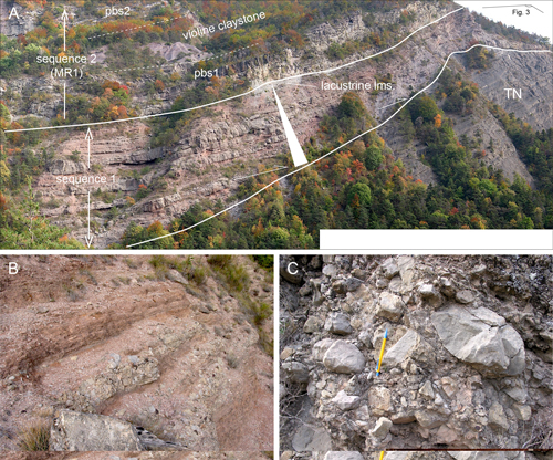
A
thick breccia system resting on Upper Jurassic limestone and marslstone (Terres
Noires Fm.) crops out along the Defens crest, just NE of Le Caire village, and
south of the Valentin thrust fault (Fig. 1.B ![]() ). The breccia beds are
clast-supported, ungraded, angular limestone clasts of local origin, sourced in
Mesozoic deposits of the subalpine basin. At the base of the sequence, breccia
beds are channelled (Fig. 3.A
). The breccia beds are
clast-supported, ungraded, angular limestone clasts of local origin, sourced in
Mesozoic deposits of the subalpine basin. At the base of the sequence, breccia
beds are channelled (Fig. 3.A ![]() ). Higher up, they are more laterally-continuous
and were, therefore, deposited as debris flow lobes. Huge debris flow beds
carrying megablocks of Tithonian limestone occur at base (Figs.
3.C
). Higher up, they are more laterally-continuous
and were, therefore, deposited as debris flow lobes. Huge debris flow beds
carrying megablocks of Tithonian limestone occur at base (Figs.
3.C ![]() ,
4
,
4 ![]() ). As a
whole, the slope of the Defens hill exposes a natural section through a
Paleogene torrential fan, oriented roughly perpendicular to the direction of the
hill crest (Fig. 3.A-B
). As a
whole, the slope of the Defens hill exposes a natural section through a
Paleogene torrential fan, oriented roughly perpendicular to the direction of the
hill crest (Fig. 3.A-B ![]() ). The succession is overall fining-up
(Figs. 3.D
). The succession is overall fining-up
(Figs. 3.D ![]() ,
4
,
4 ![]() ).
The basal breccia also occur in the next tectonic unit NE of the Valentin thrust
fault (Fig. 5.A
).
The basal breccia also occur in the next tectonic unit NE of the Valentin thrust
fault (Fig. 5.A ![]() , location on Fig. 1.B
, location on Fig. 1.B ![]() ). The outcrop being perpendicular to the
previous one, the onlap of sequence 1 deposits is visible on its basal boundary,
which truncates the Jurassic Terres Noires Formation. The facies appears overall
more distal, as claystone interbeds develop, and average grain-size decreases (Fig.
5.B
). The outcrop being perpendicular to the
previous one, the onlap of sequence 1 deposits is visible on its basal boundary,
which truncates the Jurassic Terres Noires Formation. The facies appears overall
more distal, as claystone interbeds develop, and average grain-size decreases (Fig.
5.B ![]() ). The unsorted breccia material
(Fig. 5.C
). The unsorted breccia material
(Fig. 5.C ![]() ) is chanelled within
overbank fine-grained deposits. The fact that the depositional facies is overall
more distal vs. the one observed on the Defens crest, gives the overall
orientation of the sedimentary system to the NE. The top of the sequence shows
light-grey lacustrine limestone (Figs. 5.A
) is chanelled within
overbank fine-grained deposits. The fact that the depositional facies is overall
more distal vs. the one observed on the Defens crest, gives the overall
orientation of the sedimentary system to the NE. The top of the sequence shows
light-grey lacustrine limestone (Figs. 5.A ![]() ,
7.C
,
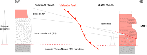
7.C ![]() ). The Valentin thrust fault (Fig. 1.B
). The Valentin thrust fault (Fig. 1.B ![]() ) clearly shortened the facies transition between a proximal torrential
system and a distal fan, which evolved with time to a lacustrine environment (Fig. 6
) clearly shortened the facies transition between a proximal torrential
system and a distal fan, which evolved with time to a lacustrine environment (Fig. 6 ![]() ).
).
Given the similarities with the Esparron syncline to the SE, the observations made in the Faucon-Turriers area suggest that the basal breccia unit (BU) belong to a full tectonostratigraphic flexural sequence, laterally-continuous, beginning with the deposition of a high-sloped torrential fan followed by the progressive flattening of the topography and the deposition of lacustrine limestones.
The
basal breccia toplaps the basal boundary of Sequence 2 and disappear to the NE
within the Grand Vallon valley (Fig. 7.A ![]() ), indicating that the bounding surface
of the overlying Sequence 2 (MR1) is rapidly truncational towards the inner Alps,
exactly the same way it is in the Esparron syncline to the SE (Ferry et al.,
2025, Fig. 9).
), indicating that the bounding surface
of the overlying Sequence 2 (MR1) is rapidly truncational towards the inner Alps,
exactly the same way it is in the Esparron syncline to the SE (Ferry et al.,
2025, Fig. 9).
|
Figure 3:
Sequence 1 along the Defens crest (location on Fig. 1.B |
|
Figure 4:
Lateral view of the Defens torrential fan showing megablocks of Tithonian
limesrtone at base, capped by la stack of laterally-continous breccia lobes, and
passing up to red claystone (fining-up sequence). |
|
Figure 5:
Downdip facies changes within sequence 1 on left bank of the Grand Vallon
valley (location on Fig. 1.B |
|
Figure 6:
Facies changes of sequence 1 deposits on both sides of the Valentin fault
(without scale). |
|
Figure 7:
Sequence 2 (MR1) on left bank of the Grand Vallon. A, general view
(explanations
in the text); pbs, point bars stacks; thickness of sequence 2 is about 250 m. B,
Close view of two stacked sandstone-filled channels showing the inclined
internal stratification of point bars. C, view of the sole cast at base of the
lower sandstone bed of picture B, oriented at high angle vs. the inclined
internal stratification, a characteristic of river bends in meandering systems,
also note the underlying light-grey limestone (lacustrine) forming the top of
sequence 1. D, closer view of the nested point bars forming the point bar stack
2 (pbs 2), center of picture A. |
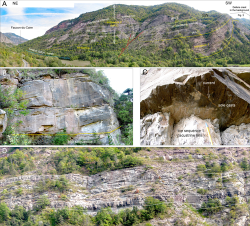
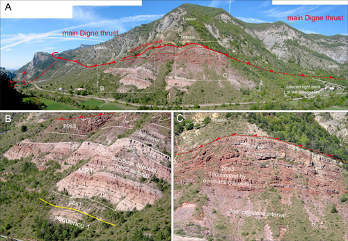
Excellent
exposures of Sequence 2 are found along the left bank of the Grand Vallon Creek,
south of Faucon-du-Caire village (Fig. 7.A ![]() ). The succession is comprised of
three sandstone intervals separated by red, pink or violet claystone (Figs.
4.A
). The succession is comprised of
three sandstone intervals separated by red, pink or violet claystone (Figs.
4.A ![]() ,
5.A
,
5.A ![]() ). The sandstone intervals consist of multistoried point-bar deposits, with
well-defined internal lateral accretion (Fig. 7.B, .D
). The sandstone intervals consist of multistoried point-bar deposits, with
well-defined internal lateral accretion (Fig. 7.B, .D ![]() ), and sole casts at the
base that are roughly perpendicular to the lateral accretion (Fig.
7.C
), and sole casts at the
base that are roughly perpendicular to the lateral accretion (Fig.
7.C ![]() ). Within
the clay-dominated intervals, scattered point bar deposits may be present amid
overbank sandstones. The depositional environment of the MR1 is that of a
meandering fluvial system, in which the stacking of point bars were the result
of the shifting of the river with time within a large valley.If they are
constrained in a narrow valley, possibly they indicate that the amalgamation
rate of point bars records changes in the subsidence rate, forming subsequences.
Three subsequences (pbs 1 to pbs 3, Fig. 7.A
). Within
the clay-dominated intervals, scattered point bar deposits may be present amid
overbank sandstones. The depositional environment of the MR1 is that of a
meandering fluvial system, in which the stacking of point bars were the result
of the shifting of the river with time within a large valley.If they are
constrained in a narrow valley, possibly they indicate that the amalgamation
rate of point bars records changes in the subsidence rate, forming subsequences.
Three subsequences (pbs 1 to pbs 3, Fig. 7.A ![]() ) are observed.
) are observed.
Sequence 2 shows a similar meandering fluvial pattern as seen at the base of MR1 in the Esparron syncline (Ferry et al., 2025). The main difference is that the succession in the Faucon-du-Caire area is much thicker, and was not buried by a prograding fluvial fan.
The
thickness of sequence 2 is 300-350 m, up to the top of the mountain (Fig.
7.A ![]() ).
The stratigraphic contact of point=bar stack pbs3 with overlying Sequence 3
deposits is only visible farther up the valley, close to Faucon-du-Caire
village.
).
The stratigraphic contact of point=bar stack pbs3 with overlying Sequence 3
deposits is only visible farther up the valley, close to Faucon-du-Caire
village.
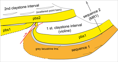
A
minor fault-propagation fold is found at the base of MR1 (Fig.
7.A ![]() ). The fault
and fold were subsequently truncated and are separated by point bar stack pbs 2
by an angular unconformity. This feature is evidence that faulting, folding and
subsequent erosion occurred during the deposition of MR1 (Fig. 8
). The fault
and fold were subsequently truncated and are separated by point bar stack pbs 2
by an angular unconformity. This feature is evidence that faulting, folding and
subsequent erosion occurred during the deposition of MR1 (Fig. 8 ![]() ).
).
The
multistory point-bar deposits found on the left bank of the Grand Vallon valley
are less prominent (pbs1) or lacking (pbs2) than along the right bank (Fig.
9.A-B ![]() ). The upper stack pbs3 is also dominated by overbanks deposits on the
right bank (Fig. 9.C
). The upper stack pbs3 is also dominated by overbanks deposits on the
right bank (Fig. 9.C ![]() ) in contrast to the left bank where thick sandstone-filled
channels are observed. This abrupt change in the succession over a short
distance suggests that the course of the meandering river was likely controlled
by the Grand Vallon fault, as deposits pinched against it, likely indicating a
change in the river course.
) in contrast to the left bank where thick sandstone-filled
channels are observed. This abrupt change in the succession over a short
distance suggests that the course of the meandering river was likely controlled
by the Grand Vallon fault, as deposits pinched against it, likely indicating a
change in the river course.
|
Figure 8:
Cartoon depicting the synsedimentary fold sealed by point bars stack pbs2,
seen on center of Figure 7.A |
|
Figure 9:
Facies changes within the MR1 on right bank of the Grand Vallon (location on
Fig. 1.B |
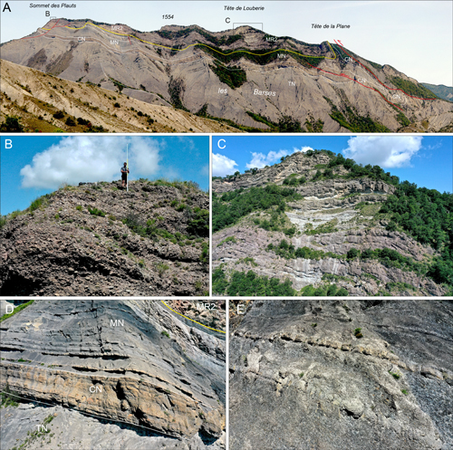
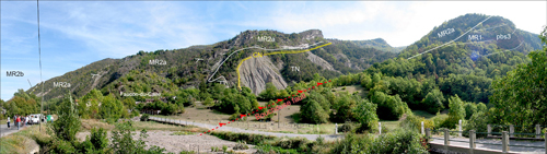
The
Molasse Rouge 2 (MR2) was analyzed through a drone footage of some crests
(Sommet des Plauts, Tęte de Louberie, Tęte de la Plane) facing the Turriers
Village to the NW (Fig. 1.B ![]() ). A section was logged along the Gigors to Faucon
road (D 951) by the Sarraut pass of the Grand Vallon valley. MR2 is poorly
exposed along the right bank of the Grand Vallon valley between Gigors and
Faucon-du-Caire villages. Geological maps (1/50.000 sheets of Laragne-Montéglin,
# 893, and of Seynes-les-Alpes, # 894) show the formation is dissected by
several thrust slice faults, which further complicates the stratigraphic
analysis of a complex fluvial system on a densely forested slope. Just south of
Faucon-du-Caire, on the left bank of the Grand Vallon valley, well-exposed
outcrops reveal stratigraphic relationships between Sequences 2 and 3 (Fig. 1.B
). A section was logged along the Gigors to Faucon
road (D 951) by the Sarraut pass of the Grand Vallon valley. MR2 is poorly
exposed along the right bank of the Grand Vallon valley between Gigors and
Faucon-du-Caire villages. Geological maps (1/50.000 sheets of Laragne-Montéglin,
# 893, and of Seynes-les-Alpes, # 894) show the formation is dissected by
several thrust slice faults, which further complicates the stratigraphic
analysis of a complex fluvial system on a densely forested slope. Just south of
Faucon-du-Caire, on the left bank of the Grand Vallon valley, well-exposed
outcrops reveal stratigraphic relationships between Sequences 2 and 3 (Fig. 1.B ![]() ).
).
The
crest NW of Turriers village exposes the stratigraphic relationships between the
Jurassic marine marlstone (Terres Noires Fm.), the base of the marine nummulitic
succession and MR2 (Fig. 10.A ![]() ). Molasse sequences 1 and 2 are not present at
this locality. S3 deposits exposed along the crest are comprised of nested
channels fills composed of a mixture of well-rounded pebbles and more angular
clasts (Fig. 10.B
). Molasse sequences 1 and 2 are not present at
this locality. S3 deposits exposed along the crest are comprised of nested
channels fills composed of a mixture of well-rounded pebbles and more angular
clasts (Fig. 10.B ![]() ). Quartzite pebbles of probable Alpine origin make up the
majority of the well-rounded material. They are associated with metamorphic "green rocks"
(serpentinites) and radiolarites from the inner Alps. The
depositional environment is interpreted as a braided stream combining angular
pebbles from distant (dominent) and local sources. Drone footage along the crest
(Fig. 10.C
). Quartzite pebbles of probable Alpine origin make up the
majority of the well-rounded material. They are associated with metamorphic "green rocks"
(serpentinites) and radiolarites from the inner Alps. The
depositional environment is interpreted as a braided stream combining angular
pebbles from distant (dominent) and local sources. Drone footage along the crest
(Fig. 10.C ![]() ) reveals interbedded conglomerate similar to that cropping out in
Figure 10.B
) reveals interbedded conglomerate similar to that cropping out in
Figure 10.B ![]() , and finer-grained material. There is a lack of lateral continuity
between these two facies, suggesting that the depositional environment was a
large, braided stream system with shifting channels producing pebble-dominated
bars, and cutting into overbank deposits. The underlying nummulitic succession
comprises a regularly bedded, fine-grained offshore limestone (Calcaire
nummulitique, Fig. 10.D
, and finer-grained material. There is a lack of lateral continuity
between these two facies, suggesting that the depositional environment was a
large, braided stream system with shifting channels producing pebble-dominated
bars, and cutting into overbank deposits. The underlying nummulitic succession
comprises a regularly bedded, fine-grained offshore limestone (Calcaire
nummulitique, Fig. 10.D ![]() ), overlain by a deeper-water, dark-gray marlstone with
interspersed fine-grained limestone beds (Marnes nummulitiques or Marnes Bleues,
Fig. 10.E
), overlain by a deeper-water, dark-gray marlstone with
interspersed fine-grained limestone beds (Marnes nummulitiques or Marnes Bleues,
Fig. 10.E ![]() ).
).
|
Figure 10:
Sequence 3 seen from the Turriers road (location on Fig. 1.B |
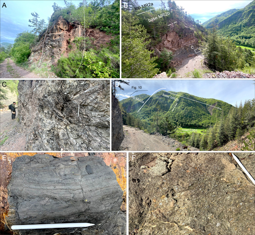
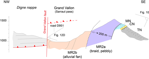
Within
the upper Grand Vallon valley, close to Gigors village (Sarraut pass, Fig. 1.B ![]() ),
MR2 deposits are vertical to overturned against the Digne thrust (Fig.
11.A
),
MR2 deposits are vertical to overturned against the Digne thrust (Fig.
11.A ![]() ).
MR2 deposits can be subdivided into a lower MR2a unit (Fig. 11.B
).
MR2 deposits can be subdivided into a lower MR2a unit (Fig. 11.B ![]() ), showing the
same pebbly facies observed on the crest facing the Turriers village (Fig.
10.B
), showing the
same pebbly facies observed on the crest facing the Turriers village (Fig.
10.B ![]() ), and an upper unit (MR2b) comprised of reddish deposits
(Fig. 11.A
), and an upper unit (MR2b) comprised of reddish deposits
(Fig. 11.A ![]() ). The
thickness of the three subunits of lower MR2 deposits (a to c, Fig.
11.B
). The
thickness of the three subunits of lower MR2 deposits (a to c, Fig.
11.B ![]() )
preserved against the Digne thrust is around 200 m. The basal reddish deposits
of MR2b consist of silty claystone with sandstone lenses interpreted as filled
channels, locally thick with lateral accretion (Fig. 12.A
)
preserved against the Digne thrust is around 200 m. The basal reddish deposits
of MR2b consist of silty claystone with sandstone lenses interpreted as filled
channels, locally thick with lateral accretion (Fig. 12.A ![]() ), indicating a sinuous
channel path. A several-meters thick interval of dark claystone is intercalated
in the basal part (Fig. 12.B-C
), indicating a sinuous
channel path. A several-meters thick interval of dark claystone is intercalated
in the basal part (Fig. 12.B-C ![]() ), likely representing the infilling of a large
abandoned channel or a swampy lowland. The claystone includes small, nested
channels filled with thin laminated sandstones, representing flood events (Fig.
12.E
), likely representing the infilling of a large
abandoned channel or a swampy lowland. The claystone includes small, nested
channels filled with thin laminated sandstones, representing flood events (Fig.
12.E ![]() ).
Channell-filled sandstone may be gravelly at base, with subrounded clasts (Fig.
12.F
).
Channell-filled sandstone may be gravelly at base, with subrounded clasts (Fig.
12.F ![]() ), in contrast to that of the well-rounded pebbly materiel of the
lower MR2. The thickness of MR2b red deposits can be more than 300 m, as
estimated from panoramas (Fig. 12.D
), in contrast to that of the well-rounded pebbly materiel of the
lower MR2. The thickness of MR2b red deposits can be more than 300 m, as
estimated from panoramas (Fig. 12.D ![]() ). A cross-section
(Fig. 13
). A cross-section
(Fig. 13 ![]() ) illustrates
stratigraphic and structural relationships.
) illustrates
stratigraphic and structural relationships.
|
Figure 11:
Sequence 3 (MR2) along the Faucon to Gigors road (location on Fig. 1.B |
|
Figure 12:
Facies of the MR2 along the Faucon to Gigors road. A, deep,
sandstone-filled channel within the basal part of the lower MR2 (MR2a). B, Base
of the upper MR2 alluvial fan (MR2b) showing a dark siltstone bed intercalated
between the red sandstone and claystone. C and E, closer views of the laminated
dark bed. D, view of the strongly dipping succession of the MR2 on the eastern
bank of the valley. The crest to the left is the crest shown on Fig. 10.C. The
total thickness of the MR2 reaches ≈ 650 m. F, view of the coarse-grained
sandstone bearing poorly-rounded gravels filling the large channels in the lower
part of the MR2. G and H, view of the overturned succession of lower MR2 (MR2a)
alluvial deposits against the Grand Vallon fault. |
|
Figure 13:
Stratigraphic organization of Sequence 3 (MR2) across the Faucon-Turriers
tectonic scale (location on Fig. 1.B |
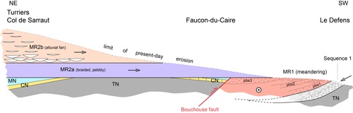
The
left bank of the Grand Vallon creek, close to Faucon-du Caire village (Fig. 14 ![]() ),
shows the stratigraphic relationships between MR1 and MR2 deposits on both sides
of the Bouchouse fault (location, Fig. 1.B
),
shows the stratigraphic relationships between MR1 and MR2 deposits on both sides
of the Bouchouse fault (location, Fig. 1.B ![]() ). Upstream, MR2 deposits rest
directly on either the Jurassic Terres Noires marlstone, or lenses of preserved
marine Nummulitic deposits, as in the area of Turriers village (Figs. 1.B
). Upstream, MR2 deposits rest
directly on either the Jurassic Terres Noires marlstone, or lenses of preserved
marine Nummulitic deposits, as in the area of Turriers village (Figs. 1.B ![]() ,
10
,
10 ![]() ).
South of the Bouchouse fault, the MR2a pebbly subunit rests unconformably on the
multistory point-bar deposits (pbs3) of the MR1 (Fig. 14
).
South of the Bouchouse fault, the MR2a pebbly subunit rests unconformably on the
multistory point-bar deposits (pbs3) of the MR1 (Fig. 14 ![]() ).
).
All
the stratigraphic data collected in the Faucon-Turriers tectonic corridor are
summarized in Figure 15 ![]() , which shows that strong tectonic deformation occurred
between deposition of MR1 and MR2.
, which shows that strong tectonic deformation occurred
between deposition of MR1 and MR2.
|
Figure 14:
Stratigraphic relationship between MR1 and MR2 around Faucon-du-Caire on
both sides of the Bouchouse fault. Abbreviations: TN, Jurassic Terres Noires
Fm.; CN, Nummulitic limestone. |
|
Figure 15:
Stratigraphic relationship between Sequence 1, Sequence 2 (MR1) and
Sequence 3 (MR2) along the eastern bank of the Grand Vallon. Arrows indicate
directions of the stream in each sequence. Tectonic units according to Gidon
(1997). |
No additional data are found vs. what was found in the previous study (Ferry et al., 2025). The age of Sequence 1 is judged to be late Rupelian, mostly because it clearly is an independent flexural sequence predating the deposition of MR1 (Sequence 2). Its basal breccia unit (BU) was often considered once as a marginal deposit of MR1. But, its age and significance remain to be discussed on a larger scale in integrating other data from in front of the Alpine chain (work to come). The two Molasse Rouges sequences (S2 and S3) belong to the Chattian.
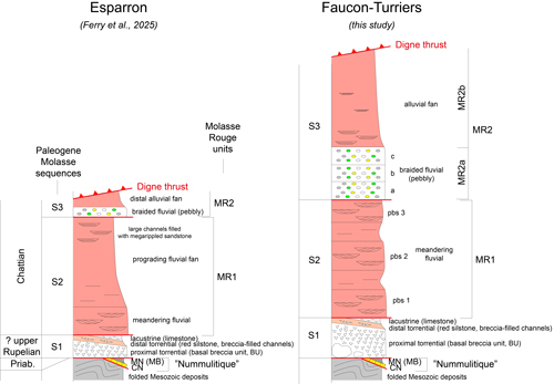
Changes
in facies and successions between the Esparron-Esclangon (Ferry et al.,
2025)
and the Faucon-Turriers (this study) areas are summarized in Figure 16 ![]() . The
three depositional sequences S1 to S3 are recognized in both localities.
Although more or less truncated by the basal boundary of Sequence 2, Sequence 1
appears to be laterally-continuous along the Alpine belt, as well as having an
internally fining-up pattern. The most pronounced facies changes are within
Sequence 2 (MR1). In the Esparron-Esclangon area, the meandering fluvial facies
is found only at the base of MR1 at Esparron, where it is overlain by a
prograding fluvial fan bearing large, thick sandstone lenses representing filled
channels with an internal braid pattern at top. To the east of Esclangon, the
meandering fluvial facičs at the base of MR1 is absent and the alluvial fan has
a different pattern. Sequence 3 (MR2) shows in both localities the same pattern
of a relatively low-sloped braided fluvial system overlain by an alluvial fan,
except for thicknesses.
. The
three depositional sequences S1 to S3 are recognized in both localities.
Although more or less truncated by the basal boundary of Sequence 2, Sequence 1
appears to be laterally-continuous along the Alpine belt, as well as having an
internally fining-up pattern. The most pronounced facies changes are within
Sequence 2 (MR1). In the Esparron-Esclangon area, the meandering fluvial facies
is found only at the base of MR1 at Esparron, where it is overlain by a
prograding fluvial fan bearing large, thick sandstone lenses representing filled
channels with an internal braid pattern at top. To the east of Esclangon, the
meandering fluvial facičs at the base of MR1 is absent and the alluvial fan has
a different pattern. Sequence 3 (MR2) shows in both localities the same pattern
of a relatively low-sloped braided fluvial system overlain by an alluvial fan,
except for thicknesses.
|
Figure 16:
Compared stratigraphic successions (Esparron-Esclangon vs. Faucon-Turriers
areas). CN,
Calcaire Nummulitique; MN, Marnes Nummulitiques (or MB, Blue Marls, as they are
also termed); pbs, point bar stacks within MR2; Priab., Priabonian. |
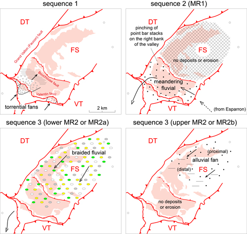
The
paleogeography for each sequence is shown in Figure 17 ![]() .
.
Outcrops
of Sequence 1 are limited to the frontal thrusts of the Digne thrust system
because it is truncated northward by those of Sequence 2 (Fig.
5.A ![]() ). The
Valentin thrust shortens the updip to downdip areal extension of the
depositional system (Fig. 6
). The
Valentin thrust shortens the updip to downdip areal extension of the
depositional system (Fig. 6 ![]() ). The areal organization of deposits is similar to
that at the NW termination of the Esparron syncline (Ferry et al.,
2025, Fig.
23.A). In each area, a belt of torrential fans is associated with high relief
adjacent to a flat-lying basin floor that opens towards the inner Alps. The
western boundary of this basin might correspond to the western boundary of the
transported Digne basin.
). The areal organization of deposits is similar to
that at the NW termination of the Esparron syncline (Ferry et al.,
2025, Fig.
23.A). In each area, a belt of torrential fans is associated with high relief
adjacent to a flat-lying basin floor that opens towards the inner Alps. The
western boundary of this basin might correspond to the western boundary of the
transported Digne basin.
It
is difficult to determine the orientation of a meandering fluvial system, due to
the dispersion of current directions. As a whole, the deposits of Sequence 2
appear to be a continuation to the NW of those found in the syncline valley of
Esparron. Accordingly, Sequence 2 deposits are also lacking to the NE in the
next tectonic scale, north of the Bouchouse fault (Figs. 1.B ![]() , 15
, 15 ![]() ). Termination
of the multistory point bar deposits against the Grand Vallon fault (Fig.
9
). Termination
of the multistory point bar deposits against the Grand Vallon fault (Fig.
9 ![]() )
suggests that the course of the river was diverted to exit the Digne nappe
around the SW termination of the Faucon-Turriers corridor (Fig. 17
)
suggests that the course of the river was diverted to exit the Digne nappe
around the SW termination of the Faucon-Turriers corridor (Fig. 17 ![]() ). This
implies that topographic relief was controlled by the Grand Vallon fault, which
would have been active at that time. The greater thickness for the meandering
stream succession of MR1 is likely due to enhanced subsidence on the eastern
compartment of the fault. From work in progress, MR1 deposits are lacking NW of
the Faucon-Turriers area where MR2 rests on folded Jurassic and Cretaceous
deposits, suggesting that the western compartment of the fault was uplifted
during the deposition of MR1. The course of the river outside the Digne nappe is
unknown, due to the scarcity of Paleogene deposits to the west. It was possibly
flowing in front of the Ventoux-Lure thrust (Fig. 1.A
). This
implies that topographic relief was controlled by the Grand Vallon fault, which
would have been active at that time. The greater thickness for the meandering
stream succession of MR1 is likely due to enhanced subsidence on the eastern
compartment of the fault. From work in progress, MR1 deposits are lacking NW of
the Faucon-Turriers area where MR2 rests on folded Jurassic and Cretaceous
deposits, suggesting that the western compartment of the fault was uplifted
during the deposition of MR1. The course of the river outside the Digne nappe is
unknown, due to the scarcity of Paleogene deposits to the west. It was possibly
flowing in front of the Ventoux-Lure thrust (Fig. 1.A ![]() ), but this needs further
investigation.
), but this needs further
investigation.
|
Figure 17:
Successive paleogeographies (Sequences 1 to 3). |
Pebble
imbrication within channel-fill deposits along the crest of Les Plauts indicates
a paleoflow direction to the SW, following the Faucon-Turriers corridor. The
path of the MR2a fluvial system flowing from the Digne nappe along the
Ventoux-Lure thrust is supported by a similar succession of channel-form
polygenic conglomerates that contain Alpine radiolarites and "green rocks"
within red claystone close to Montfroc village (Fig. 18 ![]() ). The conglomerate
infill of channels is heterogenous and composed of either entirely well-rounded
(Fig. 18.B
). The conglomerate
infill of channels is heterogenous and composed of either entirely well-rounded
(Fig. 18.B ![]() ) or mixed poorly- and well-rounded clasts
(Fig. 18.A
) or mixed poorly- and well-rounded clasts
(Fig. 18.A ![]() ). Poorly rounded
clasts are local material supplied by tributaries into the main river carrying
the well-rounded material coming from the inner Alps. This succession at
Montfroc was assigned a Miocene age (Montenat et al.,
2000) based on a
reappraisal (Garnier, 1999) of the geological map
of Séderon (Flandrin
et al., 1961) and of a
correlation with a section situated 10 km farther west (Montbrun syncline, Fig.
18.C
). Poorly rounded
clasts are local material supplied by tributaries into the main river carrying
the well-rounded material coming from the inner Alps. This succession at
Montfroc was assigned a Miocene age (Montenat et al.,
2000) based on a
reappraisal (Garnier, 1999) of the geological map
of Séderon (Flandrin
et al., 1961) and of a
correlation with a section situated 10 km farther west (Montbrun syncline, Fig.
18.C ![]() ) where a somewhat similar conglomerate rests discomformably on Miocene
deposits. According to Flandrin et al. (1961), the polygenic conglomerate observed at Montfroc
unconformably overlies Cenomanian deposits. According to Garnier
(1999), the succession
is inverted by faulting, placing the Montfroc conglomerate on Miocene deposits.
Our investigation shows that the pebble assemblages of the third Miocene
conglomerate bed at Montbrun (Montenat et al., 2000), as well as that of the
potentially coeval Montfroc conglomerate, are completely different. At Montbrun,
the conglomerate comprises only sub-rounded, fine-grained limestones clasts
reworked from the local Mesozoic Vocontian basin, in contrast to the mixed
lithologies of the Montfroc conglomerate (Fig. 18
) where a somewhat similar conglomerate rests discomformably on Miocene
deposits. According to Flandrin et al. (1961), the polygenic conglomerate observed at Montfroc
unconformably overlies Cenomanian deposits. According to Garnier
(1999), the succession
is inverted by faulting, placing the Montfroc conglomerate on Miocene deposits.
Our investigation shows that the pebble assemblages of the third Miocene
conglomerate bed at Montbrun (Montenat et al., 2000), as well as that of the
potentially coeval Montfroc conglomerate, are completely different. At Montbrun,
the conglomerate comprises only sub-rounded, fine-grained limestones clasts
reworked from the local Mesozoic Vocontian basin, in contrast to the mixed
lithologies of the Montfroc conglomerate (Fig. 18 ![]() ). The facies of the third
Montbrun conglomerate is, in fact, very similar to the Serravallian Traversiers
Conglomerate (Monier & Cavelier,
1991) observed farther west in the Comtat basin.
Their age and facies are similar. Poor outcrop conditions today at Montfroc
prevent reexamination of the nature (stratigraphic or tectonic) of formation
boundaries. On the basis of the nature of conglomerates, we reject the
correlation made by Montenat.
). The facies of the third
Montbrun conglomerate is, in fact, very similar to the Serravallian Traversiers
Conglomerate (Monier & Cavelier,
1991) observed farther west in the Comtat basin.
Their age and facies are similar. Poor outcrop conditions today at Montfroc
prevent reexamination of the nature (stratigraphic or tectonic) of formation
boundaries. On the basis of the nature of conglomerates, we reject the
correlation made by Montenat.
If
our conclusions are correct, the fluvial system of the lower MR2 (MR2a) would
have exited the paleovalley in front of the Ventoux-Lure thrust through the
breached Suzette diapir (Montmirail locality, Fig. 18.C ![]() ). However, this needs
further investigation (work in progress), including a revision of the
stratigraphic data of Huet et al. (2025) for the area around the SW wall of the
Suzette diapir (Baumes-de-Venise crest).
). However, this needs
further investigation (work in progress), including a revision of the
stratigraphic data of Huet et al. (2025) for the area around the SW wall of the
Suzette diapir (Baumes-de-Venise crest).
Currently, no data support the hypothesis that meandering river deposits of MR1 in the Digne nappe followed the same path as that of MR2 outside the nappe. An exit along the Durance fault is however not possible, as briefly discussed in Ferry et al. (2025). This, therefore, remains an open question, until the upper part of the Montmirail succession is revisited in detail.
|
Figure 18:
The Montfroc conglomerate in front of the Ventoux-Lure thrust, as a
possible outlet route to the west for the lower MR2 fluvial system. A,
conglomerate infill of channels within red claystone; B, close view showing
pebbles of inner Alpine "green rocks" and red radiolarites (arrows); D, map
showing the path of the MR1 and MR2 fluvial systems out of the Digne nappe. |
The study of the Faucon-Turriers tectonic corridor confirms the result obtained farther south within the transported basin of the Digne nappe (Ferry et al., 2025).
The basal breccia unit (BU) is a full tectonostratigraphic sequence (S1) oriented parallel to the Alps and is no longer to be considered as a mere marginal breccia facies at the base of the Molasses Rouges of other authors.
The first unit of the Molasses Rouges, stricto sensu (sequence 2 or MR1), represents the meandering fluvial infilling of a syncline paleovalley that followed the western boundary of the depositional basin. Its course shifted to the west where striking paleorelief formed by the SW-NE oriented Grand Vallon fault bounding the Faucon-Turriers corridor. Its course, then likely, followed the front of the Ventoux-Lure thrust to the west, but this remains to be better documented through a reappraisal of the Montmirail succession in the Comtat basin (middle Rhône valley).
The second unit of the Molassses Rouges (sequence 3 or MR2) represents a braided fluvial system flowing straight west from the inner Alps. Its path along the front of the Ventoux-Lure is better documented than for the MR1.
As in the Esparron syncline (Ferry et al., 2025), the depot-centres of MR1 and MR2 strongly shifted within the Digne nappe, therefore evidencing major tectonic deformation during the Chattian.
Field work by author SF was done with personal money. We are grateful to the Laboratoire de Géologie de Lyon (LGL-TPE; UMR 5276 CNRS) for funding PS, PG, and SA's fieldwork sessions.
The in-depth review of this work by W.W. Little (LG Consulting, Colorado) is greatly welcome and deeply appreciated, as well as the comments of an anonymous reviewer.
Arnaud H., Gidon M. & Pairis J.-L. (1977).- Précisions sur la structure des chaînes subalpines méridionales dans la région de Faucon-Turriers-Clamensane (Alpes de Haute-Provence).- Géologie Alpine, Grenoble, t. 53, no. 1, p. 5-34. URL: http://geologie-alpine.ujf-grenoble.fr/articles/GA_1977__53_1_5_0.pdf
Ferry S., Sorrel P., Grandjean P. & Augier S. (2025).- The peri-Alpine Paleogene Red Molasse of southeastern France - I. Esparron syncline and Esclangon area (Alpes-de-Haute-Provence).- Carnets Geol., vol. 25, no. 11, p. 219-253. DOI: 10.2110/carnets.2025.2511
Flandrin J., Gottis M., Viallix J.R., Golenko N., Riché P., Parant J. & Rebilly G. (1961).- Séderon.- Carte géologique de la France ŕ 1/50 000, Orlé́ans, Notice explicative, no. 916, 15 p. URL: http://ficheinfoterre.brgm.fr/Notices/0916N.pdf
Garnier L. (1999).- Le Miocčne au Nord de Ventoux-Lure. Évolution paléogéographique et structurale (Vaucluse, Drôme, Alpes de Haute-Provence, France).- Thčse-Mémoire de 5e année IGAL, Cergy, no. 124, 222 p.
Gidon M. (1997).- Les chaînons subalpins au nord-est de Sisteron et l'histoire tectonique de la nappe de Digne.- Géologie Alpine, Grenoble, t. 73, p. 23-57. URL: http://geologie-alpine.ujf-grenoble.fr/fitem?id=GA_1997__73__23_0
Gidon M. & Pairis J.-L. (1992).- Relations entre le charriage de la Nappe de Digne et la structure de son autochtone dans la vallée du Bčs (Alpes de Haute-Provence, France).- Eclogae geologicae Helveticae, Basel, vol. 85, no. 2, p. 327-359. URL: https://scispace.com/papers/relations-entre-le-charriage-de-la-nappe-de-digne-et-la-4c9iqu3di9
Huet B. (2024).- Dynamique des bassins d'avant-pays et collision dans les Alpes de l'Ouest : sources, routage et bilans sédimentaires.- Thčse de doctorat en Sciences de la Terre, Sorbonne Université, 251 p. URL: https://memsic.ccsd.cnrs.fr/THESES-SU/tel-05113226v1
Monier P. & Cavelier C. (1991).- Vaison-la-Romaine.- Carte géologique de la France ŕ 1/50 000, Orléans, Notice explicative, no. 915, 54 p. URL: http://ficheinfoterre.brgm.fr/Notices/0915N.pdf
Montenat C., Barrier P. & Garnier L. (2000).- La sédimentation miocčne au nord des massifs de Ventoux-Lure (chaînes subalpines méridionales).- Géologie de la France, Orléans, vol. 2000, no. 3, p. 3-32.